

Gigantic rock formations and easy trails.
Serious solitude and clean, clear air.
Welcoming locals, quiet campsites.
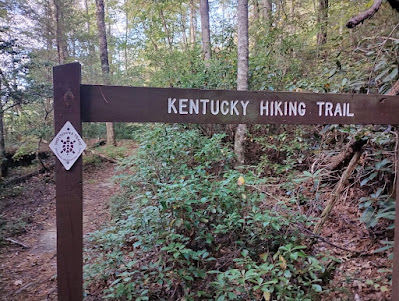
This is the relatively unknown and untrampled Sheltowee Trace Trail, one of the most relaxing, chill long distance walks I have completed.
The Sheltowee threads it's way up and down the State of Kentucky from the Northern Terminus near the University town of Morehead, spilling over the Southern border into Tennessee and the splendid Big South Fork Recreation Area.
You are in the green tunnel of the Daniel Boone National Forest for the most part with an occasional State Park and short road walk thrown in to break things up.
Signage and trail maintenance is excellent and your fellow hikers are non existent.
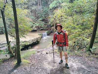
I tackled the Sheltowee with my girlfriend Fiesty Hippie over the months of September and October 2023.
 |
| Map sourced from Hiiker.com |
 |
| Map sourced from visitjacksoncountyky.org |
Getting to the Trailheads:
Cranston Road- Northern Terminus.
We flew to St Louis, Missouri and picked up a rental car which facilitated collecting supplies and getting organised for the hike far easier than running around on foot or utilising public transport.
The drive to Lexington, Kentucky via the I64 is around 550 kilometres. (Note- we could have flown directly to Lexington but I was keen on a slow, multiday road trip driving through Illinois and stopping in Indiana for a night)
We dropped the car off at Blue Grass Airport and were shuttled to the Northern Terminus on Cranston Road by lovely trail angel Denise, driving time is about 90 minutes.
We paid Denise $100 USD.
There is Sheltowee signage, parking for 5 vehicles and not much else at the Northern Terminus.
There is no public transport to the start of the Sheltowee Trace at either end of the trail so if you don't have friends or relatives in the USA willing to drop you off then contacting the wonderful Sheltowee Trace Association and asking nicely for some help to arrange a shuttle is your best bet.
That's what I did and Lucy was super cool and efficient chasing down Denise for us.
There is extensive information under Shuttle Services.


Resupply and Trail Towns:
We resupplied in the following Kentucky towns, North to South.
Supermarkets, hotels, fast food.
Small tourist minded convenience store, laundry, hotel in State Park.
Camping, cabins, hot food, basic supplies.
Supermarket, Dollar General, Air BnB's, fast food.
Gas station supplies, diner food.
Walmart, many hotels, fast food.
Small store with snacks and hot food.
Free Wifi, food kiosk.
Supermarket, restaurants, post office.
Free Wifi, basic supplies and beer at the camp store.


Flora and Fauna:


Navigation and Resources:

Weather and Landscapes:

I am surmising that a taxi or Uber from Lexington could be an option as well.
Burnt Mill Bridge- Southern Terminus.
This is the Southern end for now- the trail is being extended 10 miles or so to the small town of Rugby, Tennessee.
We arranged a pick up and shuttle to Knoxville Airport to pick up a rental car upon completion of the Sheltowee with friendly local Tiffany. Cost $150 USD.
There is parking for around 20 vehicles, trash cans and primitive bathroom facilities at Burnt Mill Bridge.


Resupply and Trail Towns:
We resupplied in the following Kentucky towns, North to South.
- Morehead. Mile 25 / Kilometer 40 - on trail
Supermarkets, hotels, fast food.
- Red River Gorge, Slade. Mile 87 / Kilometer 140 - on trail
Small tourist minded convenience store, laundry, hotel in State Park.
- Linda Lago RV Sites. Mile 104 / Kilometer 167 - 1 mile off trail
Camping, cabins, hot food, basic supplies.
- McKee. Mile 141 / Kilometer 227 - 2 miles off trail
Supermarket, Dollar General, Air BnB's, fast food.
- 49er Truck Stop. Mile 177 / Kilometer 285 - on trail
Gas station supplies, diner food.
- London. Mile 202 / Kilometer 325 - 16 miles off trail
Walmart, many hotels, fast food.
- Holly Bay Marina. Mile 205 / Kilometer 330 - .5 mile off trail
Small store with snacks and hot food.
- Cumberland Falls State Park. Mile 223 / Kilometer 359 - on trail
Free Wifi, food kiosk.
- Whitley City. Mile 254 / Kilometer 408 - 4 miles off trail
Supermarket, restaurants, post office.
- Bandy Creek Campground. Mile 312 / Kilometer 502 - on trail
Free Wifi, basic supplies and beer at the camp store.


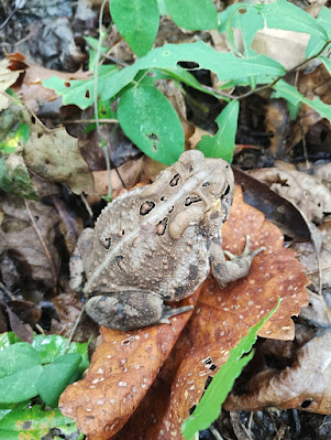
The woods of Kentucky are very lush, very green. Very pretty.
We walked under Hickory and Beech trees, Oaks, White Pines, Yellowwoods, Maples, Yellow Poplars and alongside Dogwoods and Holly's.
I was constantly on the look out for poison ivy and poison oak and fortunately only got licked once while falling over like a dickhead. I treated the impending blisters with hydrocortisone cream and pretended I wasn't scratching like a loon when the itch got too much.
Ticks were a non issue on our hike. We treated our shoes, packs and tent in Sawyer permethrin, checked each others filth encrusted bodies at the end of the day and had no dramas. Chiggers on the other hand gave our legs a bit of a hiding.
Liberal coatings of Sawyer Picaridin insect repellent made no impact and my calves were nailed with bites.
No visits from Mr Bear and no racoon sightings which was weird.
Actually not much in the way of typical Eastern State wildlife was encountered aside from copious amounts of scurrying squirrels, a few whitetail deer, an abundant birdlife and hundreds of spider webs strung across the trail at times.
Crawfish and frogs were seen often in the clear waters and we occasionally helped an Eastern Box Turtle off the trail into the scrub.
I reckon the hunting enthusiasts of Kentucky have possibly done too enthusiastic a job of annihilating the larger native mammals in the trail locale.
Or they are just super shy.


I used the Farout App and the Sheltowee Trace guide on my phone.
Loads of information on there from other hikers. Farout Sheltowee guide.
I purchased a T mobile pre pay Sim card for my phone in St Louis. Coverage was spotty but most of the time there were a few bars on the high points of the trail when required, such as booking a room or chasing a weather forecast.
Again, the STA website is the best place to gather information. STA website.
Jupiter's Youtube clips of his hike in 2019 are worth a watch too. Jupiter 2019 Sheltowee Thru.
The Sheltowee Trace Association Facebook group was really helpful in answering my queries regarding ticks and shuttle services.


Camping:
I had a blast camping on this trail.
The Farout guide lists some established sites suitable to throw a tent up but really anywhere on public land is fair game. At times we would do a little 'chickening'; light clearing of leaf and branches to clean a space for our Big Agnes Tiger Wall tent.
We often had a fire, sipped some skanky Fireball and chewed a gummie. No issues with hunters or other trail users as there weren't any other people on this trail, we were alone every single night.
Worst case was when we were rained on by acorns being dislodged by squirrels high up in the canopy. Big deal right!
Every now and then you stumble onto an established site complete with table, fire ring and wood stacked up which is a bonus.
Water:
Depending on when you head out on the track the creeks could be flowing or you may be restricted to scooping from puddles. The occasional spigot is listed on the guide and for the most part the water sourced from streams and creeks was clean and clear. I filtered with a Sawyer Squeeze every single time.
And no I am not sponsored by Sawyer, I just really like their stuff, it's what I used and it's widely available at REI and Walmart.


September and October proved an optimal time for us this year. Not too hot, not too cold, bit sweaty on the uphill climbs, mostly shorts and t shirt weather.
Fiesty wore a $1 Goodwill dress and I bumbled around in synthetic running shorts and shirt most of the time. A few days of rain had us hauling our jackets out of the bottom of our packs but we were blessed with stable climatic conditions for the most part.
I would classify walking the Sheltowee as easy.
Aside from the churned up boggy ATV tracks strewn with garbage (shame on you Kentucky locals who desecrate your beautiful lands with beer cans and Arby's wrappers) the forestry roads and single track are mostly well maintained and conducive to really nice walking.
A few dilapidated bridges and also some missing bridges add a little adventure to river crossings and a couple of steep hill climbs worked me over, however it's a trail anyone could walk.
There is a chunk of road walking south of Heidelberg unofficially known as the 'dog walk section' where you can meet every variety of ferocious, unchained, off lead redneck canine possible.
They race out to greet you with a mouth full of sharp teeth and a bad attitude for around a 40 mile stretch.
I was forewarned of these pesky critters and had a small canister of pepper spray at the ready every time an angry dog intent on eating my nutsack charged at us.
Fortunately we never had an serious problems and managed to shoo the rascals away but then again there were 2 of us and I am guessing that previous attacks on hikers running the gauntlet of Lamero Cruise Road and Crestmont Road has influenced local authorities to enforce these lazy owners of the dogs to restrain and contain most of them.
I love dogs but not these arseholes.
They wouldn't stop me from hiking the Sheltowee again but it really shouldn't be an issue, even in the back blocks of Kentucky.
Obviously it's the owners that are the root of the problem, the true arseholes.
But in any case you have been informed.

Thoughts:

This was my first hike in the States since before the pandemic thing.
Quite a bit has changed.
Prices for everything are far higher; food, hotels, fuel, rental cars.
The word is that there are far more people on the popular trails, hence why I chose to go wander where most don't. Crowded trails suck.
Some things haven't changed.
Southern hospitality and people wanting to help me on my journey is still mind blowing amazing, I mean it.
Kentucky has some of the kindest trail enthusiasts in the country, thank you legends!
This was the longest timeframe I have hiked with another person; we took a cruisey 28 days to complete the Sheltowee with 2 zero days thrown in there.
I was forced to compromise my ingrained hiking habits that hankered for long walking days and higher mileage and slow down, enjoy the woods and another persons company. Sweet!
The Sheltowee Trace is a fantastic walking path, totally recommended and thoroughly enjoyed.
Thank you trail angels and STA members for your kindness and helping us on our way.
