Friday 26 August 2022

Heysen Trail Thru Hike. 1100km, 40 days. South Australia.


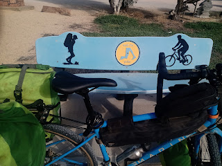
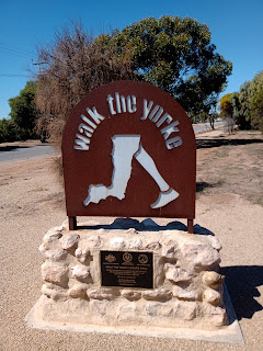
The Heysen Trail; Australia's longest marked footpath at around 1100 kilometres of rough desert, dirty sheep paddocks, country roads and outback towns and a banger of a Southern coastline.

It's hilly, it's dry, it's peppered with huts and fantastic lookouts and for now, right now; you can have the whole righteous ramble to yourself.  
The popularity of the often crowded Bibbulmun Track (Australia's other 1000 kilometre walk in Western Australia) hasn't transferred over to the Heysen and hopefully it stays that way.

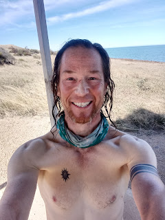
I hiked the Heysen Southbound over 40 days in June/ July 2022 with a couple of zero days in Quorn and Victor Harbor, respectively.
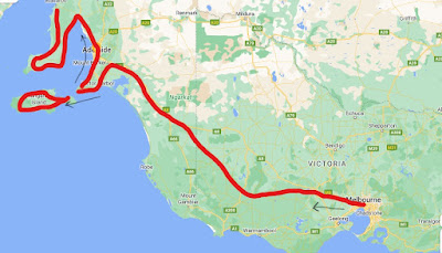
Map sourced from Google Maps.


Map sourced from Friends of the Heysen Trail.

Getting to and from the Trailheads:

North-  I pre booked the once weekly Genesis shuttle from Adelaide central bus station that departs 7:30am on Thursday's.  
It's a smallish vehicle that contained 3 of us would be end to end Heysen hikers (only one hardy legend made it to Cape Jervis which gives you an idea of the strike rate) and a variety of other passengers jumping off at various dusty towns on the way.  

The bus spits you out at the Parachilna turnoff and the last 17 kilometres is a choose your own adventure between thrifty road walking for a few hours or paying a boofy bloke in a boofy 4WD blasting Beyonce shizz a fist full of dollars for a speedy drop off.  

We reached the Parachilna trailhead around 1:30pm via boofy guy in boofy 4WD.

The return journey back to Adelaide from Parachilna for Northbound hikers runs on Friday's.
www.genesistransport.com.au for all lowdown.

South-  The Sealink bus makes a daily run to Cape Jervis departing from the Adelaide central bus station at 3:30pm, arriving at the Southern trailhead around 5:15pm, $27.

I caught the daily Cape Jervis up to Adelaide shuttle with Sealink ($27) departing 9:30am, arriving Adelaide 11:25am.


Resupply and Trail Towns:

The second best thing about the Heysen is the crazy little outback towns the trail pokes through on it's wiggly route.

I carried 3 or 4 days food at a time and stocked up at:

  • Wilpena-          Good IGA supermarket.  Butane gas cannisters.
  • Quorn-             Small supermarket and great hiker hostel; Elizabeth House.  Gas.
  • Melrose-           Adequate general store and spacious, cheap camping/ caravan park. Gas.
  • Crystal Brook- Good supermarket, pharmacy. Gas.
  • Spalding-          Adequate general store. Gas.
  • Burra-               Good supermarket and town with full facilities. Gas.
  • Kapunda-          Large supermarket and my favourite trail town.  I stayed overnight on a whim                                and had a blast. Gas.
  • Tanunda-           Large supermarket, full on tourist town.
  • Bridgewater-     Coles supermarket.
  • Mt Compass-    Good supermarket.
  • Heysen's Rest Hiker Cabins. Great overnight stop between Mt Compass and Robinson's Hill campsite.  Definitely go the full breakfast next morning. No resupply.
  • Inman's Valley General Store- No resupply but 100% recommend grabbing a feed off the menu if the kitchen is kicking. Cafe.
  • Victor Harbor-    Largest town near the Heysen (7 kilometres off trail), Coles and Woolworths. Gas.

All towns have somewhere to procure water and food to go. There is usually a pub room and/or campsite to crash in too. 

Dining is generally restricted to simple Aussie pubs with a generic menu and general stores flipping a toasted sandwich at you but the larger tourist towns such as Tanunda and Victor Harbor contain many fast food options and a higher standard of accommodation if that floats your boat.

Water is scarce on the trail.

I completely relied on the tanks situated in the walker campsites.  Camel up and fill the bottles when you can.  I never filtered any water and never got sick.  Your call, you do you.
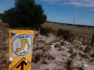


Navigation and Resources:

I gave up my curmudgeon ways and downloaded the Far Out Heysen Trail mapping file, shunned all paper maps and kept a sharp eye out for oft sighted Heysen marker posts as I bumbled along fencelines and dry creek beds.

The Friends of the Heysen are a bunch of super cool walking heroes that maintain and protect and improve the trail.  Kudos you badasses!

The website is here.

Strongly consider throwing them a donation after walking on the Heysen.  


Camping:

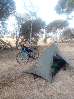
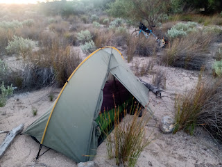
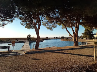
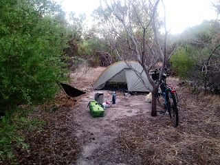
Most nights were spent plonked out in a super quiet spot either stealth camping in the bush wherever I pleased or in the official hiker walk in sites.  These official sites are often located on private land and  consist of a bench and water tank and flat ground to throw up the tent, like the photo below of Eyre Depot.

There are loads of huts and shelters as well.  I avoided these like herpes as most hikers seem to gravitate to a roof and walls when it's available and I value my solitude.  

I dunno, I spend enough nights indoors so when I am finally out hiking in the woods the nylon walls of my tent and the stars twinkling above seem like bliss.  But the backcountry huts are there if you get excited about mice running over your face in the middle of the night or drunk bogans playing bush warriors on a Saturday evening.  

All hut hate aside, I'm the first to admit they are great for holing up or taking a break when the weather is hooting down.


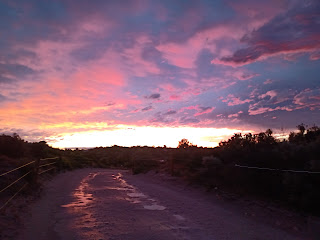
Weather and Landscape:

Most of the Heysen Trail is closed during the Summer months due to bushfire risk, particularly where it wends over private land.

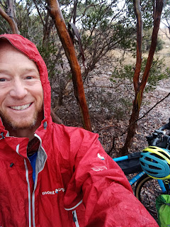
I hiked it in the Winter and lucked out with mostly fine, settled weather.  Temps slid down to single digits in the early morning and up to early teens mid afternoon. 

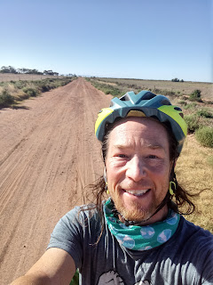
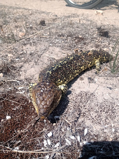
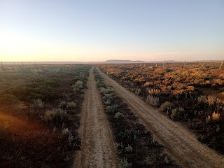
The Northern area around the Flinder's Ranges National Park features alpine desert forest, spiky spinifex, rocky bluffs and many kilometers trudging in dry creek beds.

After descending Mt Remarkable and rolling through Melrose it's green farm country with a few small conservation parks dotted about.  
I witnessed loads of slippery lambs being born and the sound of baaing sheep was the soundtrack to my walk.

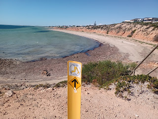
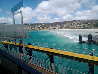
South of Adelaide you are charging towards the coast and beautiful sheer cliffs and sandy beaches.

There's much variation in landscape and plenty of surprises.   If you don't mind a bit of quiet road walking and straddling 2000 odd fence stiles then a Winter walk of this path through South Australia is a solid choice.


Thoughts:

I was never bored on this hike.  Never wanted to be somewhere else.  Didn't really want it to end either.  I slowed right down in the South and dragged out the last 200 kilometres as long as I could.

Positives:
  • It's unpopular but that's changing, evolving.  You get solitude but increasing trail services and friendly locals that kind of know what your doing.  
  • Empty campsites and great intel via the Far Out app.
  • Well marked trail, easy resupply.
  • Mobile coverage is good.  If you want that.
Not so positive:

  • I heard the occasional bit of gunfire on this walk, as you do. One Saturday night while attempting to stealth camp outside Wilmington a drunk bogan in a 4WD skidded to stop near my tent and proceeded to blast away into the bush, probably random Roo shooting.  I froze and hoped for the best and listened to him swear and stomp around and completely miss seeing me and after Mr Trigger-happy Fuckface departed in a hail of gravel I packed up quick smart and bailed into Wilmington, camping on the Golf Course.  There are a couple of reports floating around of wild Friday and Saturday nights around Wilmington involving firearms experienced by bewildered hikers.
  • The trail is quite exposed.  Not many bug out spots aside from the trail towns and no shelter other than the huts.
  • If you are chasing a wild landscape with dreamy mountain vistas and alpine lakes then the mundane agricultural land in the middle of the Heysen may disappoint.  I just loved being out there but that's me.
Would I hike the Heysen again?  Fuck yes. 

Any questions, give me a hoy.  safarihiker@gmail.com


Wednesday 25 May 2022

Great Dividing Trail- Bendigo to Bacchus Marsh, Victoria, Australia. 200km.


Map sourced from www.gdt.org.au


An hours train ride North West of Melbourne is the 300 kilometre long, 3 forked Great Dividing Trail Network linking the country city of Bendigo with Daylesford and onward to either Bacchus Marsh and Ballarat, depending on the direction you choose.

The softly undulating track winds through ripped up mining traces, gigantic eucalpyt tree forests, lovely looping singletrack and rutted forestry roads.  

There are large populations of bouncy native mammals crashing about and abundant birdlife  squawking and flapping and yahooing around.

Resupply is easy but water can be scarce.  

I walked from Bendigo to Bacchus Marsh in May, 2022.  Almost always alone, I met no other walkers, only a few mountain  bikers and camped where ever I wanted.   

No access issues, no dumb bogans, very little road walking.

If you want a budget friendly, easily accessible, week long hike near Melbourne then the GDT is a fantastic option.  I had a mighty time, lets crack on...

Map sourced from Google Maps.

Getting To the Trailhead:

Bendigo and Bacchus Marsh are served by regular Vline trains that shuttle back and forth many times a day to and from Southern Cross station in central Melbourne.

The trip up to Bendigo took around 2 hours and cost around $24, off peak fare. 

I purchased a Myki card from a machine for $6 (non refundable) and added $32 credit onto it to cover the fare to Bendigo and also the fare from Bacchus Marsh back to Melbourne a week later (around $6).

Vline train fares and timetable here.

Note: There is no formal signage at these train stations announcing the GDT terminus'.   


Water Situation:

This is the kicker.  Although the trail crosses many streams and creeks, many of them are seasonal and dry for much of the year.  I sourced water from public taps and faucets in parks and picnic areas around the towns and localities and made sure I was carrying enough to get me through 15km or so of walking.  At the end of a day I loaded up with H20 where possible in case I ended up dry camping on a ridge which is what I usually did.

There are also quite a few mineral springs with public faucets you pump up and down for a bit that I encountered and utilised.  You won't die of dehydration on the GDT but I suggest grabbing every opportunity that pokes it's head up for a drink.

Most of the picnic shelters have a power socket to charge your phone too if you search around hard enough.


Camping:

Plenty of trees and flat spots and privacy to camp wherever you want.

Day 1-  Bushland 10km South of Bendigo near the water race.

Day 2-  Slope below Mt Alexander.

Day 3-  Bushland 2km North of Fryerstown.  (Fryerstown has a Community Hall with toilets and water and undercover area, camping permitted.)

Day 4-  Bushland above Hepburn Springs.

Day 5-  Bushland 10km South of Daylesford.

Day 6-  Nolan Creek Picnic Area.  (I didn't see the no camping sign until the following day but no one disturbed me and a small fire on a frosty night was welcome.)

Day 7-  Bushland along Nolan's Track.  (Locked gate, walkers only.)

Day 8-  Pentland Council Sports Oval Toilet.  (I rocked into the outskirts of Bacchus Marsh on a Saturday evening and it was either $45 for an unpowered tent site or $556 for an Air BnB.  Instead, I chose a fairly clean toilet cubicle that the security guard didn't check was empty and then neglected to lock it correctly, thankfully for me. 


Resupply:

Options galore.

  • Bendigo itself has a Woolworths supermarket and shops right beside the train station.

  • Castlemaine has IGA supermarkets and shops and the trail goes right into town.

  • Daylesford is a really cool and yes, touristy town with a Coles supermarket and loads of cafes.

  • Blackwood has a great Post Office/ Cafe with a good bakery and coffee.

  • Bacchus Marsh has a Coles supermarket and shops and is easy to navigate.

I purchased a butane gas cannister from Bogong outdoor equipment store in Melbourne before boarding the train to Bendigo.


Navigation and Resources:

There are maps available from the official Great Dividing Trail website here.

I chose to download the free GPX files from the website of the Lederderg Track (Daylesford to Bacchus Marsh), the Dry Diggings Track (Castlemaine to Daylesford ) and the Leanganook Track (Bendigo to Castlemaine) and open them on the Gaia app. GPX links here. 

This was free and ample for working out where I was on trail.  

Track signage is excellent.  

The guides are available in the Visitor Information Centres in the major towns along the trail as well.

I also purchased the Lederderg Park map (below) from Bogong in Melbourne for $11.


Final Thoughts:

I did this walk on a slim budget, wanting to see how cheap I could take things and still have a great time out in the woods.  This hiking area so close to Melbourne and a sizeable local regional population was for the most part uber peaceful and all about the solitude.  
I exchanged a few greetings with the odd mountain biker or dog walker but was mostly alone and I had a blast heading Southbound.

Big thanks and hugs to the legends who maintain this trail network!


Sunday 20 March 2022

Cycle touring: Melbourne to Kangaroo Island and Walk The Yorke Trail 2000km, 4 weeks.


Safari the hiker rolls off on a tangent and becomes Safaribiker for a while. 

I've knocked over the first leg of my push around the big island (Australian mainland) and that includes a smaller one too; Kangaroo Island off the Southern coast of South Australia where I rested my red raw arse and briefly made a bit of coin. 

-I'm not a 'cyclist'.

-I don't wear lycra.

-I briefly considered walking around Australia but cut that idea loose as too much of a dreary trudge.

So a blue steel gravel bike with 4 lime green panniers was my mode of transport and fuck me it's been a wee bit of fun. 

THE ROUTE:  I rode off the Spirit of Tasmania ferry and pointed the bike North West to Ballarat via some C roads (minor roads, both paved and gravel), through the Wimmera and across South Australia to Cape Jervis where I hopped another ferry to Kangaroo Island, Australia's 3rd largest island.  

The last time I was at Cape Jervis I was heading off on the Heysen Trail from the Southern Terminus located there.

After poking around the windy interior and the wild coastline I pushed North through Adelaide to the Yorke Peninsula and followed the 500km Walk The Yorke trail from Port Wakefield to Moonta Bay.


Fancy map of my riding route sourced from Google Maps.

THE EQUIPMENT: 

  • Marin Four Corners Gravel Touring Bike. 
  • Ortlieb panniers, large ones for the rear, small for the front.
  • Tubus pack rack carriers.
  • Heaps of spare inner tubes.  Slime.  Tools to hopefully fix shit that went wrong.
  • Camping and cooking kit I always use for hiking.
  • A fuck ton of sunscreen.
REALITY OF BICYCLE TOURING:

There are plenty of silly Youtube videos and pretty pictures all over the interwebs depicting long distance bicycle touring as this isolating, beautiful experience where amazing vistas are constantly stumbled onto and friendly fairies and unicorns are only a short 5 kilometre ride away. 

While some of this is true some of the time, I discovered while riding around rural Australia at the tail end of Summer; 

that the roads can be very busy, 

the roads are mostly narrow and crap with minimal shoulder, 

many Australians have a pathological hatred of cyclists 

and bike repair shops are few and far between when out of the major cities.

when I reached purpose built/ designated bicycle trails such as the Ballarat to Skipton trail and the amazing rail trail from Willunga to central Adelaide the fun factor increased by 10.  

Regardless, I had a very positive experience.  Hell yeah!

On the whole people were very encouraging and drivers courteous.  Even if they weren't I reminded myself that I had chosen to be out there, on the gravel shoulder of the road pedaling away like a loon and no one owed me anything.  

I actually got sick of the waving and fist pumps and friendly tooting, I just wanted to be alone and stop being looked at.  

That's the difference between hiking and riding that is the deal breaker for me; I can disappear into the woods on foot.  I'm an extroverted introvert that prefers my own company.

But I had plenty of serendipitous moments and reasons to throw fist pumps of my own.


PROS & CONS OF BICYCLE TOURING:

PROS:

  • Potential to eat far more healthy than hiking due to the access to fresh food and at times, regular shopping outlets.
  • Plans can be made up on the fly, changed, totally shit canned and resurrected with minimal energy expenditure.  Going an hour out of your way unintentionally isn't the imagined mood breaking disaster it might be if you had done it on foot.
  • Stealth camping only requires a little push into the bushes.
  • You can carry more stuff and more weight without breaking your back.  For example I packed a small collapsible chair to use when camped out which was pretty much every night. 
  • Mileage wasn't consistent but I averaged 120 kilometres a day.  Enough to feel you are a long way from where you were yesterday.

CONS:

  • The absolute reliance on mechanical componentry.  Granted mine was mostly bombproof and well suited but constant niggles and flat tyres can detract from enjoyment.  The what if factor.
  • Being stared at by everyone.  People driving past.  People sitting in their caravans.  The roo's in the paddocks.  And the sheep. Nah, they're ok.  People in caravans driving past.  Staring, staring.
  • The potential for catastrophic disaster.. Like I said though, most folks are courteous and it's more the draining hyper awareness on busy main roads that grinds.
  • As a solo shopper I was always pushing it to get back to my bike.  The potential for theft of gear is always there.  In one obviously dodgy town in South Australia I pulled the panniers off the bike and stuck them in a trolley and wheeled it around the supermarket, the risk was too high.
  • Wind sucks.
  • Hills suck.  When they face uphill.
  • Corrugated roads suck.
  • Rain sucks.
  • The broiling, brain splitting Summer Sun sucks. Whine, whine, whinge, whinge. 


IMPRESSIONS OF THE WALK THE YORKE HIKING/ CYCLING TRAIL:

The Walk The Yorke trail is a dual walking, cycling route that utilises quiet roads, purpose built pathways and coastal tracks.  At 500 kilometres in length it sticks to the very edge of the boot shaped Yorke Penninsula and is well signed with open sided shelters scattered along public road side stops.

There is a good GPS mapping service; Far Out, I used that pinpoints where you are offline.  The official maps are quite pricey. 

The entire pennisula is desert like.  Flat. Dry.  Very, very little shade.  Water can be sourced from occasional faucets and taps in towns and from rainwater tanks at the shelters if they contain any water at the time.

The coastline and beaches are very lush.  I swam and got excited (pic above), saw dolphins, stupendous sunsets, too many fleshy, well fed fishermen charging around in noisy boats, learned to take the bicycle alternate road routes when confronted with a sandy beach walk and always found a thick grove of trees and bushes to quietly put my tent up in at the end of the day.

Inland, off the trail, the towns of Mindalton and Yorketown were refreshing to pick up supplies and escape the heavy crowds of caravanners and party people and jet skiers and beach enthusiasts.

There are plenty of small towns with adequate shops along the way but water is a bit limited, that would be a consideration if I was walking the trail.  Saying that, I probably wouldn't walk this trail.  Far too much exposure being out in the open with no cover hardly at all.  The caravan parks were fully booked the entire week I rolled around the region, I was fortunate in that I could just keep riding fairly effortlessly until I found an isolated conservation park or wherever to pull up in.  

However the trail IS in my opinion more suited to walking than riding.  The constant bicycle detours that shoot you off on minor roads when the route chugs over a sand dune or soft, unrideable pathway mean you miss out on much of the best scenery and if you accidently judge the upcoming section as bike rideable and it's not then be prepared for a bit of foul language and self flagellation.  And deep sand slogging.  I had a couple of those episodes.

Walking it would be all grunt work with a low fun factor (for me that is) but full kudos to those that do it!


Map of Walk The Yorke sourced from www.heysentrail.asn.au


Shingleback Lizard, also known as a Stumpy tail.  Loads of them were sighted crossing the roads.


This is the Port Wakefield terminus of the Walk The Yorke.


Penneshaw Ferry Terminal, Kangaroo Island.

This puncture incident on the sketchy Duke Highway had me stripping the tyre off and replacing the tube.  It looked like an echidna quill had gotten embedded in the tyre somehow!  An echidna is kinda like an Australian version of a fat hedgehog or a porcupine with shorter quills.  Really fuckin hard tyre busting quills.